Object Record / FI-EPH-044
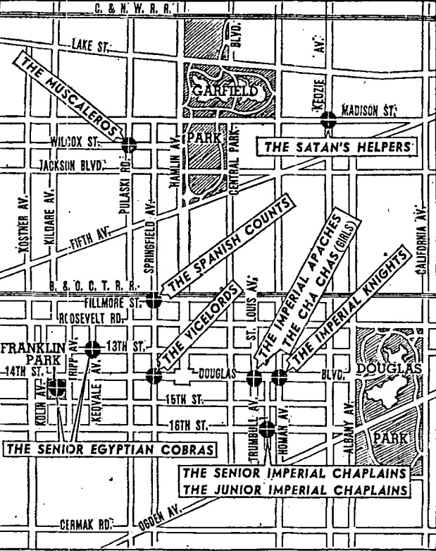
West Side Gang Territory Map
digital / JPEG, 619×781 / map / origin unverified / accessioned / catalogued curio
Primary evidence
The object before the record.
Narrative record
Evidence, relevance, and unresolved state.
Provenance
Custody record
Logged 2026-09-26 / quantity 1 digital image. 1 source asset reference registered.
Identification notes
What is known
Found image supplied for The Shadow Zone: a scanned black-and-white newspaper-style map of a street grid bounded by Garfield Park and Douglas Park, with streets such as Pulaski Rd., Madison St., and Ogden Av. Callout labels pin named groups to intersections, including "The Vicelords," "The Spanish Counts," "The Satan's Helpers," "The Imperial Knights," and "The Senior Egyptian Cobras." The street names suggest Chicago's West Side, but the publication, its date, and the accuracy of the territories are unverified and reproduced as found. Maker, origin, and date are not recorded. The exif scrub reported no location metadata to strip.
Restoration relevance
Why it remains connected
accessioned / catalogued curio. Disposition: archive. The object remains associated with The Shadow Zone.
Uncertainty notes
What remains unresolved
digital / JPEG, 619×781 / map / origin unverified. accessioned / catalogued curio. Terms marked unknown, provisional, pending, or unverified remain part of the record until evidence resolves them.
Relationships
Keep the object connected.
Related objects
Parent system
The Shadow Zone
A holding zone for surreal found media and uncanny artifacts that surface around the archive — images with no clear origin, kept as evidence of the culture that accretes on forgotten machines.
Associated dossier / FI-PROJ-010 / open
Field logs / dossiers
Archive routes
Source Assets / 1 reference
Raw archive paths are retained for provenance and maintenance. They are not the primary object presentation.
-
assets/ephemera/shadow-zone/fi-eph-044-west-side-gang-map.jpegOpen local asset